
 Depuis 2017, l’Observatoire Volcanologique de Yellowstone publie des rapports annuels qui contiennent des informations sur des sujets tels que la déformation du sol, l’activité sismique et les améliorations apportées aux réseaux de surveillance. De plus, il y a des informations sur les dernières études et les nouvelles découvertes, avec celle d’une nouvelle zone hydrothermale près du lac Tern en 2018.
Le rapport annuel 2022 vient d’être publié et peut être consulté en cliquant sur ce lien:
https://doi.org/10.3133/cir1508.
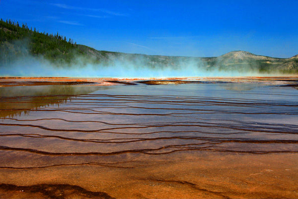
Photo: C. Grandpey
En voici le résumé :
L’Observatoire Volcanologique de Yellowstone (YVO) surveille l’activité volcanique et hydrothermale liée au système magmatique de Yellowstone. L’Observatoire effectue des recherches sur les processus magmatiques en cours sous la caldeira et, le cas échéant, émet des bulletins d’alerte et des conseils concernant les risques géologiques potentiels.
Le dernier rapport du YVO présente un résumé de activité à Yellowstone au cours de l’année 2022, en se concentrant sur le système volcanique. L’Observatoire s’attarde en particulier sur le déploiement de sismomètres dans le Norris Geyser Basin et l’Upper Geyser Basin pour étudier les interactions entre les phénomènes hydrothermaux et les influences externes.

Norris Geyser Basin (Photo: C. Grandpey)
Les scientifiques ont procédé à l’étude géologique de l’activité hydrothermale post-glaciaire, la datation plus précise des unités volcaniques de Yellowstone et la mise à jour des cartes existantes des dépôts géologiques. Ils ont établi une nouvelle cartographie des dépôts des coulées de cendres sur le dôme de Sour Creek, installé une nouvelle station de surveillance en continu des gaz près de Mud Volcano.
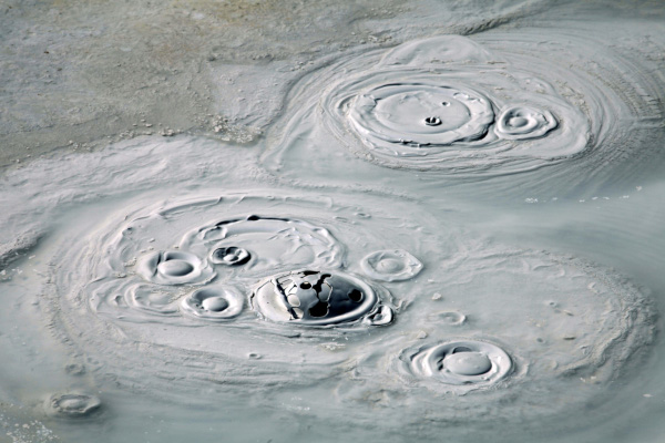
Photo: C. Grandpey
L’Observatoire a également procédé à un, échantillonnage des émissions de gaz et des eaux thermales autour du Parc national de Yellowstone pour surveiller la chimie de l’eau dans l’espace et temps. Il a effectué un travail de recherche sur l’âge et l’histoire du Steamboat Geyser dans le Norris Geyser Basin et évalué la production thermique basée sur l’imagerie satellite et le taux de chlorure dans les rivières.
L’événement le plus remarquable de l’année 2022 a été météorologique. Les abondantes précipitations et la fonte de la neige ont provoqué d’importantes inondations dans le Parc national de Yellowstone. Elles ont endommagé les routes et les infrastructures du parc.
Le Steamboat Geyser, dans le Norris Geyser Basin, a continué à montrer des éruptions fréquentes qui avaient commencé en 2018. On a enregistré 11 éruptions en 2022, ce qui représente toutefois le nombre le plus faible d’éruptions annuelles dans la séquence éruptive actuelle.
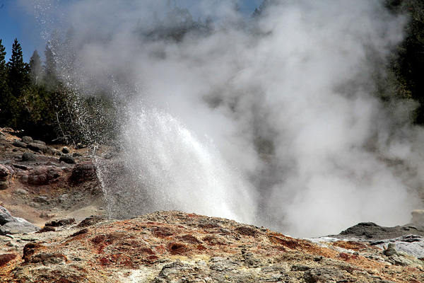
Photo: C. Grandpey
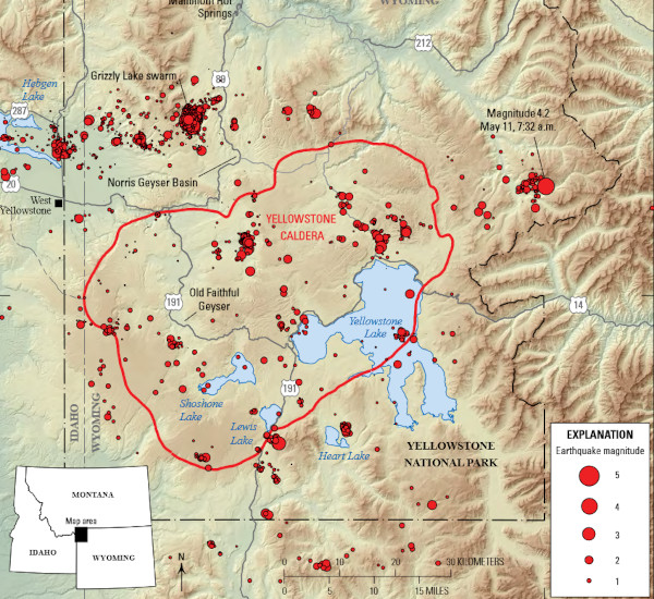
Globalement, la sismicité – avec 2 429 événements – a été légèrement inférieure aux 2 773 séismes enregistrés en 2021 et se situe à l’extrémité supérieure de la fourchette moyenne historique d’environ 1 500 à 2 500 séismes par an.
Source: YVO
L’affaissement du plancher de la caldeira, en cours depuis fin 2015 ou début 2016, s’est poursuivi à raison de quelques centimètres par an. Les mesures de déformation par satellite indiquaient la possibilité d’un léger soulèvement d’environ 1 centimètre le long du bord nord de la caldeira en 2021, mais les données satellitaires couvrant 2022 ne montrent aucun soulèvement dans cette zone.
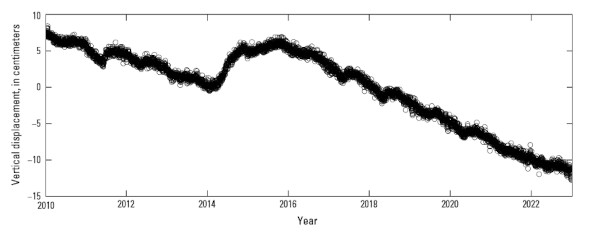
Source: YVO
Tout au long de 2022, la couleur de l’alerte aérienne pour la caldeira de Yellowstone est restée au « Vert » et le niveau d’alerte volcanique a été maintenu à « Normal ».
——————————————-
 Since 2017, the Yellowstone Volcano Observatory has produced annual reports that contain an abundance of information about a variety of topics such as ground deformation trends, earthquake activity and upgrades to monitoring networks. In addition, there is information about research results and new discoveries, like the recognition of the new thermal area near Tern Lake in 2018.
The 2022 YVO annual report was just published and is now available online at:
https://doi.org/10.3133/cir1508.
Here is the report’s abstract :
The Yellowstone Volcano Observatory (YVO) monitors volcanic and hydrothermal activity associated with the Yellowstone magmatic system, carries out research into magmatic processes occurring beneath Yellowstone Caldera, and issues timely warnings and guidance related to potential future geologic hazards.
The 2022 report summarizes the activities and findings of YVO during that year, focusing on the Yellowstone volcanic system. Highlights of YVO research and related activities during 2022 include deployments of seismometers in Norris Geyser Basin and Upper Geyser Basin to investigate interactions between hydrothermal features and influences from external influences, geological studies of post-glacial hydrothermal activity, refining the ages of Yellowstone volcanic units and updating existing maps of geologic deposits, new mapping of ash-flow deposits on the Sour Creek dome, installation of a new continuous gas monitoring station near Mud Volcano, sampling of gas emissions and thermal waters around Yellowstone National Park to monitor water chemistry over space and time, research into the age and history of Steamboat Geyser in Norris Geyser Basin, and assessment of thermal output based on satellite imagery and chloride flux in rivers.
The most noteworthy event of the year was not geophysical, but meteorological. Combined runoff from rain and snowmelt caused substantial flooding in Yellowstone National Park, which caused damage to park roads and infrastructure.
Steamboat Geyser, in Norris Geyser Basin, continued the pattern of frequent eruptions that began in 2018 with 11 water eruptions in 2022, the lowest number of annual eruptions in the current eruptive sequence.
Total seismicity—2,429 located earthquakes—was slightly less than the 2,773 earthquakes located in 2021 and at the upper end of the historical average range of about 1,500–2,500 earthquakes per year.
Overall subsidence of the caldera floor, ongoing since late 2015 or early 2016, continued at rates of a few centimeters (1–2 inches) per year. Satellite deformation measurements indicated the possibility of slight uplift amounting to about 1 centimeter (less than 1 inch) along the north caldera rim in 2021, but satellite data spanning 2022 show no uplift in that area. Throughout 2022, the aviation color code for Yellowstone Caldera remained at “green” and the volcano alert level remained at “normal.”


