Bogoslof (Alaska): Avant et après le 28 mai 2017 // Before and after May 28th 2017

Comme je l’ai indiqué dans une note précédente, le Bogoslof a été secoué par une violente éruption explosive le 28 mai 2017 qui a eu de profonds impacts sur l’île. Le volcan a émis de volumineux panaches de gaz et de cendre qui sont montés à plus de 10500 mètres d’altitude. L’événement a duré environ 55 minutes.

Voici deux images satellites qui montrent l’Ile Bogoslof avant et après l’éruption du 28 mai 2017.

Source: Digital Globe.

https://www.digitalglobe.com/

———————————–

As I put it in a previous post, Bogoslof Volcano was shaken on May 28th 2017 by a powerful explosive eruption which had major impacts on the island. The volcano spewed ash and gas more than 10,500 metres in the air during an event that lasted 55 minutes.

Here are two satellite images of the island before and after the eruption of May 28th 2017.

Source: Digital Globe.

https://www.digitalglobe.com/

Source: Digital Globe.


Les volcans vus par Thomas Pesquet // Volcanoes as seen by Thomas Pesquet

L’astronaute français Thomas Pesquet a atterri sans encombre, vendredi, dans les steppes du Kazakhstan, avec son coéquipier russe, après six mois passés dans l’ISS, la station spatiale internationale.

La mission de notre compatriote a été une réussite technique, mais aussi un extraordinaire succès populaire et un exemple de communication avec l’espace. Son fil Twitter regorge de superbes clichés de la Terre pris depuis la Cupola, ce balcon vitré offrant une vue imprenable sur notre planète. L’astronaute a beaucoup communiqué avec les médias, mais aussi avec les scolaires, notamment grâce à Astro Pi, suivi par de nombreux établissements.
Il y avait très longtemps – depuis le dernier atterrissage de la navette spatiale Atlantis –  que je n’avais pas regardé une fin de mission astronautique. C’est avec grand plaisir que j’ai assisté vendredi au retour de Thomas Pesquet, dans le cadre d’une émission qui se tenait au Centre National d’Etudes Spatiales, avec la présence d’anciens astronautes et du président Emmanuel Macron qui a eu parfaitement raison de se déplacer pour assister à cet événement.

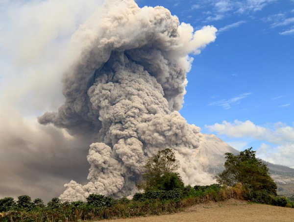
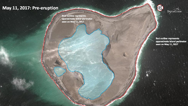
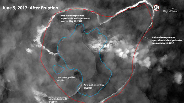
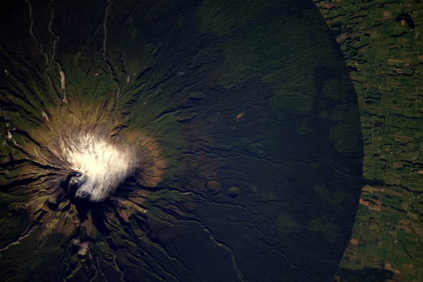
Voici quelques images de volcans photographiés par Thomas Pesquet depuis la Cupola de l’ISS.

————————————-

French astronaut Thomas Pesquet landed safely on Friday in the steppes of Kazakhstan with his Russian  colleague after six months spent in the International Space Station.
The mission performed by our compatriot was a technical success, but also an extraordinary popular success and an example of communication with space. His Twitter feed is packed with great snapshots of the Earth taken from the Cupola, the balcony with a breathtaking view of our planet. The astronaut communicated extensively with the media, but also with the students, thanks to Astro Pi, followed by many schools.
It was a very long time – since the last landing of the Space Shuttle Atlantis – that I had not watched an astronautical mission. It was with great pleasure that I watched on Friday the return of Thomas Pesquet, during a program that was held at the National Center for Space Studies, with the presence of former astronauts and President Emmanuel Macron who was perfectly right to move to attend this event.
Here are some images of volcanoes photographed by Thomas Pesquet from the ISS Cupola.

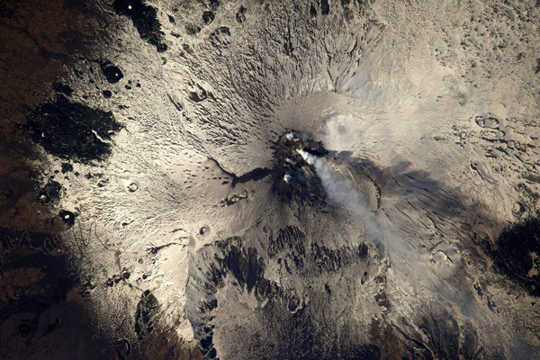
L’Etna (Sicile) en mars 2017.

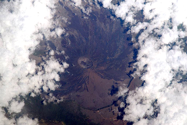
Le Piton de la Fournaise (Ile de la Réunion) au coeur des nuages

Le Taranaki (Nouvelle Zélande)

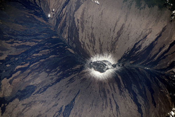
Le cratère du Mauna Loa (Hawaii).

Plus près de nous, les Monts du Cantal avec le Plateau du Coyan, encadré par la vallée de la Cère et celle de la Jordanne.

[Photos: Thomas Pesquet]

Le fonds Krafft menacé à Nancy // The Krafft heritage under threat in Nancy (France)

Mauvaise nouvelle pour la science en général et la volcanologie en particulier. La liquidation judiciaire du Centre Image Lorraine (CIL), situé à Nancy, a dernièrement été prononcée. La structure, qui possède un fonds de deux millions de photos et de 30 000 films inédits, a été fermée dans la foulée. Les fonds du CIL, primés à plusieurs reprises par le passé, pourraient dans le meilleur des cas être repris par Imag’Est Epinal si le liquidateur judiciaire l’autorise. Les collections photographiques pourraient également être transférées dans le futur Centre des mémoires de Meurthe-et-Moselle qui devrait voir le jour d’ici 2018.

Parmi les trésors du CIL figurent les archives volcanologiques de Katia et Maurice Krafft, tragiquement disparus pendant l’éruption de l’Unzen (Japon) en 1991. Les documents accumulés par Haroun Tazieff avaient, eux aussi, été très menacés après le décès de l’épouse du célèbre volcanologue.

Il faut espérer que les institutions mentionnées dans l’article de presse, et d’autres comme le Muséum d’Histoire Naturelle ou Vulcania, pourront protéger ce précieux patrimoine scientifique.

Source : BLE Lorraine.

Malheureusement, de nos jours, Culture et Patrimoine ont tendance à devenir des gros mots et les autorités locales préfèrent allouer leur argent à d’autres secteurs d’activité. Nancy n’est pas une exception. Ainsi, la municipalité de Limoges a réduit ses subventions à la Bibliothèque Francophone Multimédia qui doit désormais faire payer ses adhérents, et les associations culturelles locales – dont les subventions ont été diminuées – doivent puiser dans leurs budgets pour utiliser les structures municipales.

———————————–

Bad news for science in general and volcanology in particular. The judicial liquidation of the Centre Image Lorraine (CIL), located in Nancy, has recently been pronounced. The structure, which has a fund of two million photographs and 30,000 films, was closed in the wake. CIL funds, which have been awarded several times in the past, could at best be taken over by Imag’Est Epinal if authorized by the liquidator. Photographic collections could also be transferred to the future Memorial Center of Meurthe-et-Moselle, which is expected to be completed by 2018.
Among the treasures of the CIL are the volcanological archives of Katia and Maurice Krafft, who died during the eruption of Mt Unzen (Japan) in 1991. The documents accumulated by Haroun Tazieff had also been greatly threatened after the death of the wife of the famous volcanologist.
It is to be hoped that the institutions mentioned in the press article, and others like the Museum of Natural History or Vulcania, will be able to protect this precious scientific heritage.
Source: BLE Lorraine.

Unfortunately, nowadays, Culture and Heritage tend to become dirty words and local authorities prefer to allocate their money to other sectors of activity. Nancy is no exception. For example, the municipality of Limoges has reduced its subsidies to the Bibliothèque Francophone Multimédia, which now has to charge its members, and local cultural associations – whose subsidies have been reduced – must use their budgets to use municipal structures.

Crédit photo: Wikipedia.

Il faut espérer que le fonds Krafft sera protégé et ne se limitera pas à ces quelques objets… (Photos: C. Grandpey)

La fonte du Groenland en photos // Photos of Greenland’s melting

La fonte du Groenland est visible au niveau des glaciers qui se fracturent et vêlent de plus en plus d’icebergs. Elle se produit aussi à la surface de la banquise où sont apparues des taches bleues qui trahissent des lacs de glace fondue qui sont de plus en plus nombreux et s’agrandissent chaque année. Chaque été, ils apparaissent aussi davantage à l’intérieur des terres et à de plus hautes altitudes que par le passé. Au travers de ses photos, le photographe aérien allemand Timo Lieber dévoile un paysage inattendu du Groenland.

Le projet photographique de Timo Lieber est intitulé Thaw (« fonte », en anglais). A la croisée de la photographie artistique et de la science, il est le fruit d’une collaboration entre le photographe et une équipe de glaciologues. Leur objectif est d’alerter sur la rapide et inquiétante fonte de la calotte glaciaire qui recouvre le Groenland, la plus importante de l’hémisphère Nord.

Timo Lieber explique que « dans ce paysage immaculé, dépouillé au strict minimum de couleurs et de formes, l’impact dramatique du changement climatique est plus manifeste que dans n’importe quelle autre partie du monde […] Cela fait peur à voir de ses propres yeux. Même depuis mon avion de ligne, lors de mon arrivée au Groenland, on pouvait déjà voir le bleu des lacs. On s’attend à un paysage complètement blanc, mais en fait, ce n’est pas du tout le cas ». C’est exactement ce que je me suis dit en survolant le Groenland en septembre 2016 alors que je me rendais en Alaska.

Même si elles traitent d’un sujet grave, les photos de Timo Lieber n’en restent pas moins belles. « Je n’essaie pas d’embellir le problème lui-même », confie Timo Lieber. « Je veux que les gens qui voient ces images se posent cette question : ‘Qu’est-ce qu’il y a derrière toute cette beauté ?' »

Le portfolio groenlandais de Timo Lieber est visible à cette adresse.

http://www.timolieber.com/thaw/view/thaw-1/

Source : France Info.

—————————————-

The melting of Greenland can be seen at the glaciers which fracture and calve more and more icebergs. It also occurs on the surface of the ice sheet, where blue spots have appeared, betraying melt lakes which are increasingly numerous and growing every year. Each summer, they also appear more inland and at higher altitudes than in the past. Through his photos, the German aerial photographer Timo Lieber unveils an unexpected landscape of Greenland.
The photographic project of Timo Lieber is entitled « Thaw ». At the crossroads of artistic photography and science, it is the fruit of a collaboration between the photographer and a team of glaciologists. Their objective is to alert to the rapid and worrying melting of the ice sheet covering Greenland, the largest in the northern hemisphere.
Timo Lieber explains that « in this immaculate landscape, stripped to the bare minimum of colours and shapes, the dramatic impact of climate change is more evident than in any other part of the world … It’s scary to be seen with one’s own eyes. Even from my airliner, when I arrived in Greenland, I could already see the blue of the lakes.We expect a completely white landscape, but in fact it is not at all the case ». That is exactly what I said to myself while flying over Greenland in September 2016.
Even if they deal with a serious subject, Timo Lieber’s photos remain no less beautiful. « I’m not trying to embellish the problem itself, » says Lieber. « I want people who see these images to ask themselves, ‘What’s behind all this beauty?' »
Tom Lieber’s Greenland portfolio can be seen at this address:
http://www.timolieber.com/thaw/view/thaw-1/

Source: France Info.

Photo: C. Grandpey