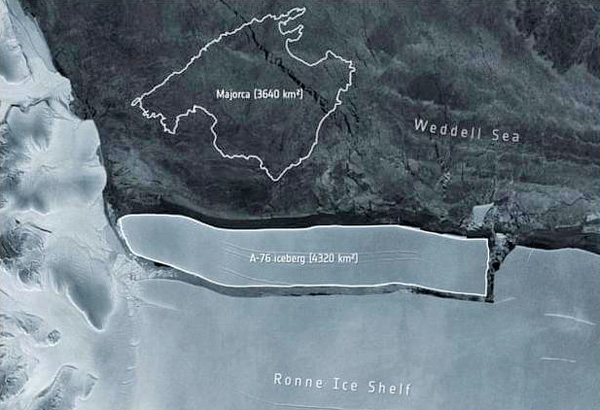
 Un iceberg géant mesurant170 km de long sur 25 km de large, pour une surface totale de 4.320 km² s’est détaché de la plateforme de Ronne en Antarctique. Selon les médias, c’est actuellement le plus gros iceberg au monde. Il est aussi grand que la moitié de la Corse et plus grand que l’île de Majorque aux Baléares.
A sa naissance, il est toutefois moins grand que l’A-68 qui s’est détaché du segment Larsen C de la Barrière de Larsen en juillet 2017. L’A-68 présentait une longueur de 175 km, une largeur de 50 km, pour une superficie de 5 800 km2, soit deux fois la taille du Luxembourg..
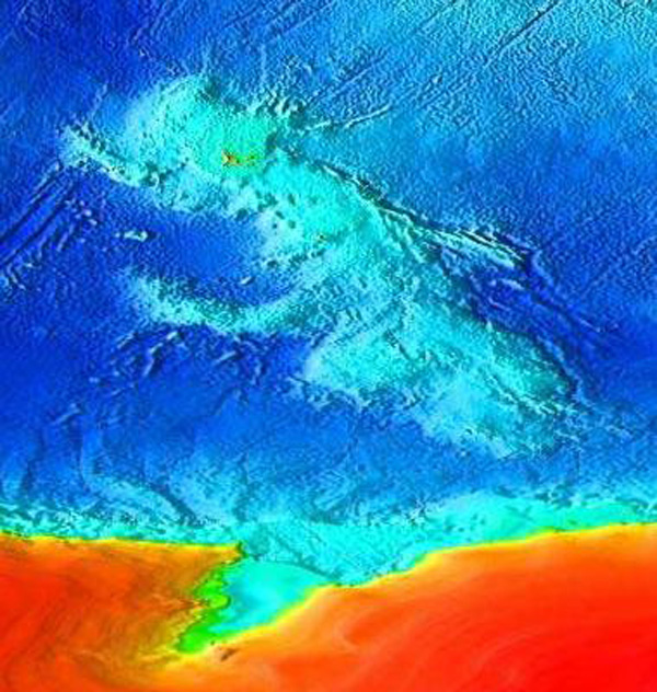
Baptisé A-76, le dernier iceberg géant a été repéré par le British Antarctic Survey (BAS) qui a une base non loin de là. De plus, l’Agence spatiale européenne (ESA) a publié une image de la rupture de l’iceberg avec la banquise, capturée par le satellite Sentinel-1 du programme Copernicus.
Le 26 février 2021, un iceberg de 1.270 km², soit environ deux fois la taille de Chicago, avait déjà quitté la partie septentrionale de la plateforme glaciaire de Brunt
Le vêlage d’icebergs dans les zones polaires n’est pas forcément provoqué par le réchauffement climatique. C’est un phénomène qui a toujours existé mais il est vrai qu’il a tendance à s’accélérer depuis quelques années. L’Ouest Antarctique où se produit le vêlage de ces gros icebergs doit faire face au réchauffement des eaux de l’Océan Austral qui viennent saper la base des plateformes glaciaires et les fragilisent, ce qui favorise la libération d’icebergs.
Il ne faut pas oublier non plus que les plateformes glaciaires retiennent souvent des glaciers. Si elles disparaissaient, ces glaciers – comme le Thwaites – accéléreraient leur course vers l’océan où ils contribueraient à faire monter le niveau de la mer.
Il va falloir maintenant suivre la trajectoire adoptée par l’A-76. On se souvient que l’A-68 avait menacé un temps de venir s’échouer le long de la côte de Géorgie du Sud, ce qui aurait fortement perturbé la faune qui s’y trouve.
°°°°°°°°°°
Pendant ce temps, l’Arctique transpire. Le 19 mai 2021, le thermomètre a dépassé 30°C au niveau du Cercle Polaire. La température est de 20 à 24°C supérieure à la normale pour cette période de l’année. Plus à l’es, à Salekhard, on prévoit une température de 26°C le 21 mai.
Moscou a battu des records vieux d’un siècle les 17 et 18 mai 2021 avec 29°2 C .
—————————————-
 A giant iceberg measuring 170 km long and 25 km wide, with a total area of 4,320 km², broke off from the Ronne ice shelf in Antarctica. According to media reports, it is currently the biggest iceberg in the world. It is as big as half of Corsica and bigger than the island of Mallorca in the Balearic Islands.
At birth, however, it was smaller than the A-68 which broke away from the Larsen C segment of the Larsen Barrier in July 2017. The A-68 had a length of 175 km, a width of 50 km , for an area of 5,800 km2, which is twice the size of Luxembourg. Dubbed A-76, the last giant iceberg was spotted by the British Antarctic Survey (BAS) which has a base not far away. In addition, the European Space Agency (ESA) has released an image of the iceberg breaking from the ice shelf, captured by the Sentinel-1 satellite of the Copernicus program.
By February 26th, 2021, a 1,270-km² iceberg, roughly twice the size of Chicago, had already left the northern part of the Brunt Ice Shelf.
Iceberg calving in polar regions is not necessarily caused by global warming. This is a phenomenon that has always existed, but it is true that it has tended to accelerate in recent years. West Antarctica, where the calving of these large icebergs takes place, has to contend with the warming of the waters of the Southern Ocean which undermine the base of the ice shelves and weaken them, which favours the release of icebergs.
It should also be remembered that ice shelves often hold back glaciers. If they were to collapse, these glaciers – like the Thwaites – would speed up their course towards the ocean where they would help raise sea levels.
We will now have to follow the trajectory adopted by the A-76. We can remember that the A-68 threatened to run aground along the coast of South Georgia, which would have seriously disturbed the fauna there.
°°°°°°°°°°
Meantime, it is hot in the Arctic. On May 19th, 2021, temperatures reached more than 30 ºC in the Arctic Circle, with the western Russian Arctic now 20 to 24 ºC hotter than normal for this time of May. Further east, in Salekhard, meteorologists forecast the heat to climb to 26 °C by May 21st.
Moscow smashed heat temperature records over 100 years old for the second consecutive day on May 18th, 2021, with 29.2 °C.
Source : ESA