Hunga Tonga-Hunga Ha’apai (archipel des Tonga / Tonga archipelago)

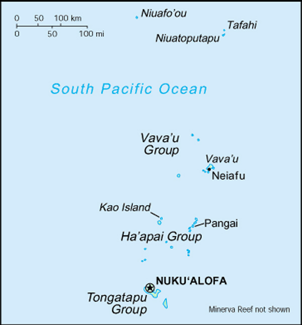
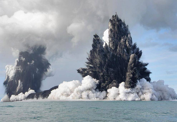
Dans une note publiée le 29 décembre 2021, j’indiquais qu’une nouvelle éruption avait débuté le 19 décembre à Hunga Tonga-Hunga Ha’apai dans l’archipel des Tonga, avec un panache de vapeur s’élevant jusqu’à 6 km d’altitude.
Le gouvernement des Tonga et le Wellington VAAC donnent plus d’informations sur cet événement. On peut lire que l’éruption a baissé d’intensité au cours des premiers jours de janvier 2022. Plusieurs épisodes surtseyens pouvant durer jusqu’à 30 minutes se sont produits au cours des derniers jours de décembre 2021 avec des panaches de gaz, de vapeur et de cendres s’élevant parfois à 12 km d’altitude Une décoloration de l’eau ainsi que des bancs de pierre ponce étaient visibles autour de l’île le 30 décembre et avaient déjà été observés depuis le début de l’éruption.
Quelques panaches de vapeur et de gaz étaient parfois visibles dans les données satellitaires les 1er et 2 janvier 2022.
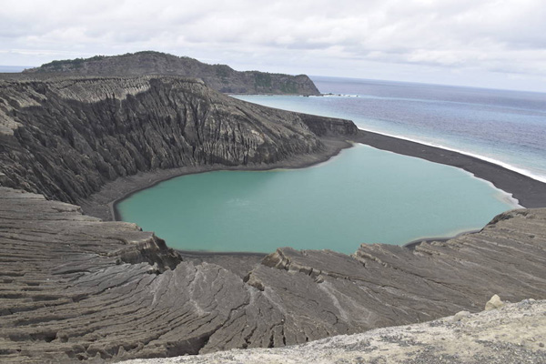
La Smithsonian Institution explique que les petites îles de Hunga Tonga et Hunga Ha’apai constituent le sommet d’un volcan sous-marin situé à environ 30 km au SSE de Falcon Island. Les deux îles andésitiques de forme linéaire mesurent environ 2 km de long et représentent les vestiges ouest et nord de la lèvre d’une caldeira en grande partie immergée située à l’est et au sud des îles. Un haut-fond rocheux à 3,2 km au SE de Hunga Ha’apai et à 3 km au sud de Hunga Tonga marque le principal centre éruptif actif. Plusieurs éruptions sous-marines se sont produites à Hunga Tonga-Hunga Ha’apai depuis la première observée en 1912.
Je vous invite à lire plusieurs notes écrites à propos de Hunga Tonga-Hunga Ha’apai entre 2015 et 2017. Les derniers articles intitulés

« Hunga Tonga-Hunga Ha’apai : La naissance d’une île »
https://claudegrandpeyvolcansetglaciers.com/2019/02/09/a-la-decouverte-de-hunga-tonga-hunga-haapai-discovery-of-hunga-tonga-hunga-haapai/

« A la découverte de Hunga Tonga-Hunga Ha’apai »
https://claudegrandpeyvolcansetglaciers.com/2017/12/13/hunga-tonga-hunga-haapai-royaume-des-tonga-pacifique-sud-histoire-de-la-naissance-dune-ile-the-birth-of-an-island/

donnent plus de détails sur ces îles spectaculaires.

—————————————–

In a post released on December 29th, 2021, I indicated that a new eruption had started on December 19th at Hunga Tonga-Hunga Ha’apai in the Tonga archipelago, with a steam plume rising up to 6 km above sea level.

The Government of Tonga and the Wellington VAAC give more information about this event. One can read that the eruption decreased in the first days of January 2022. Several surges of Surtseyan activity, with some periods lasting as long as 30 minutes, occurred during the last days of December 2021 with gas, steam, and ash plumes rising at least to 12 km a.s.l. Discolored water and rafts of pumice were visible in areas around the island on December 30th, and had been observed since the beginning of the eruption.
A few steam-and-gas plumes were occasionally visible in satellite data on January 1st and 2nd, 2022. .

The Smithsonian Institution explains that the small islands of Hunga Tonga and Hunga Ha’apai cap a large seamount located about 30 km SSE of Falcon Island. The two linear andesitic islands are about 2 km long and represent the western and northern remnants of the rim of a largely submarine caldera lying east and south of the islands. A rocky shoal 3.2 km SE of Hunga Ha’apai and 3 km south of Hunga Tonga marks the most prominent historically active vent. Several submarine eruptions have occurred at Hunga Tonga-Hunga Ha’apai since the first historical eruption in 1912.

I invite you to read several posts I wrote about Hunga Tonga-Hunga Ha’apai betwen 2015 and 2017. The latest posts entitled

« Hunga Tonga-Hunga Ha’apai : The birth of an island »

A la découverte de Hunga Tonga-Hunga Ha’apai // Discovery of Hunga Tonga-Hunga Ha’apai

« Discovery of Hunga Tonga-Hunga Ha’apai »

Hunga Tonga-Hunga Ha’apai (Royaume des Tonga / Pacifique Sud) : Histoire de la naissance d’une île // The birth of an island

give more details about these spectacular islands.

Vue de l’arc Tonga-Kermadec

Crédit photo : NASA


Hunga Tonga & Hunga Ha’apai (Archipel des Tonga)

drapeau francaisRappelez-vous: En décembre 2014, un volcan sous-marin est entré en éruption dans la région des Tonga (voir ma note du 30 décembre 2014). Un mois plus tard, lorsque l’éruption a cessé et une fois nuage de cendre dissipé, les scientifiques ont pu observer la nouvelle île que l’éruption avait laissée derrière elle. Les images ci-dessous ont été acquises par l’Operational Land Imager (OLI) à bord du satellite Landsat 8.
L’image du haut montre la région le 2 décembre 2013, un an avant l’éruption. À cette époque, les petites îles de Hunga Tonga (à droite) et Hunga Ha’apai (à gauche) étaient encore séparées l’une de l’autre par l’océan Pacifique Sud.
La seconde image montre la même zone le 28 avril 2015, quatre mois après l’éruption.
Selon un rapport publié en janvier 2015 par les autorités tongiennes, la nouvelle île entre Hunga Tonga et Hunga Ha’apai se dressait à environ 120 mètres au dessus du niveau de la mer. Elle mesurait 1,5 km du nord au sud, et 2 km de l’ouest à l’est. Tandis que les matériaux volcaniques la reliaient à Hunga Ha’apai à l’ouest, il manquait quelques centaines de mètres pour la connecter à Hunga Tonga à l’est.

Source : NASA

 ——————————————–

drapeau anglaisRemember: In December 2014, an undersea volcano erupted in the Kingdom of Tonga (see my note of December 30th 2014). A month later, when the eruption had ceased and the ash cloud had cleared, experts got a better look of the new island the eruption had left behind.

The images below were acquired by the Operational Land Imager (OLI) on the Landsat 8 satellite.

The top image shows the area on December 2nd, 2013, one year prior to the eruption. At that point, the small islands of Hunga Tonga (right) and Hunga Ha’apai (left) were separated by the South Pacific Ocean.

The second image shows the same area on April 28th, 2015, four months after the eruption.

According to a report released in January 2015 by Tongan authorities, the new island between Hunga Tonga and Hunga Ha’apai rose about 120 metres above sea level. It measured just 1.5 kilometres from north to south, and 2 kilometres from west to east. And while volcanic material connected the new island with Hunga Ha’apai to the west, it was a few hundred metres short of connecting with Hunga Tonga.

Source: NASA

Tonga-1

Tonga-2

Source:  NASA.

Hunga Ha’apai (Iles Tonga): L’éruption est terminée // The eruption is over

drapeau francaisD’après les autorités des Iles Tonga, l’éruption qui a débuté il y a environ cinq semaines est maintenant terminée. La bouche active n’émet plus de cendre, de gaz ou de vapeur. La nouvelle terre formée par l’éruption présente une hauteur d’environ 120 mètres pour une largeur qui varie entre 1,5  et 2 km. Cette nouvelle terre est collée à Hunga Ha’apai et se trouve à environ 200 mètres de Hunga Tonga. Au cours de l’éruption, toute la zone était recouverte de cendre de couleur sombre mais l’oxydation a donné une couleur plus claire à tous ces dépôts.

Source : New Zealand Herald.

 ——————————————-

drapeau anglaisAccording to authorities in Tonga, the eruption which started around five weeks is now over. There is no sign of any emissions of ash, gas or steam coming from the eruptive vent. The new land mass is about 120 metres high with a width of 1.5 – 2 km. It has joined with Hunga Ha’apai and is about 200 metres short of Hunga Tonga. The area was covered with dark coloured ash from the eruption but oxidation has changed the sediments into lighter colours.
Source: New Zealand Herald.

Hunga Ha’apai (Tonga): Nouvelles photos // More photos

drapeau francaisDes scientifiques tonguiens et néo-zélandais se sont rendus ce week-end sur le site de l’éruption entre Hunga Tonga et Hunga Ha’apai. Ils ont pu constater que les explosions de cendre continuaient mais que l’activité était beaucoup moins intense que ces derniers jours et surtout ces dernières semaines. Les explosions se produisent à raison de 2 ou 3 événements par heure ; certaines explosions latérales expédient des projections jusqu’à un kilomètre de la bouche active.

Cela fait plusieurs jours que l’on n’observe plus d’émissions de cendre susceptibles d’affecter le trafic aérien. Les vols internationaux et intérieurs se déroulent normalement.

L’éruption a sa source sur la nouvelle île qui a commencé à se construire il y a environ un mois. Il n’y a aucune trace de bancs de ponce ou autres débris volcaniques à la surface de la mer. Aucune forte odeur de gaz volcanique n’a été détectée pendant la visite.

Comme je l’ai indiqué précédemment, l’éruption en cours ressemble fortement à celle de 2009 à Hunga Ha’apai, mais la quantité de matériaux émis est beaucoup plus importante.

En cliquant sur le lien ci-dessous, vous verrez quelques bonnes photos de l’éruption prises le 17 janvier 2015.

http://matangitonga.to/2015/01/19/geo-survey-reports-less-ash-coming-volcano

Source : Matangi Tonga Online.

 ——————————————

drapeau anglaisA survey of the volcanic activity between Hunga Tonga and Hunga Ha’apai over the weekend by New Zealand and Tonga scientists found that while ash eruptions are continuing the activity appears to be much less than in previous days and weeks. There are still a few small black ash eruptions at a rate of 2 or 3 events during the hour. Lateral explosions are occasionally extending up to one kilometre from the vent.

Substantial ash emissions to the altitudes at which aircraft fly have not been observed for several days. International and domestic flights have operated without interruption in the last few days.

The eruption is continuing from the new island that started growing a month ago. No trace of rafts of pumice or other floating volcanic debris was observed. No strong smells of volcanic gases were noticed within two nautical miles of the site.

As I put it before, the style of the eruption is similar to that at Hunga Ha’apai in 2009, but the volume of material erupted this time is much greater.

By clicking on this link, you will see several good photos of the eruption taken on January 17th 2015.

http://matangitonga.to/2015/01/19/geo-survey-reports-less-ash-coming-volcano

Source : Matangi Tonga Online.

Tonga-blog