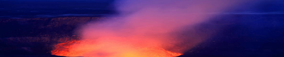
Quand on parle de volcans en Antarctique, on pense immédiatement au Mont Erebus (3,794 m) sur l’Île de Ross, mais les fonds marins autour du continent blanc offrent également des édifices volcaniques très intéressants. De nouvelles cartes haute résolution des fonds marins de la région, à mi-chemin entre la Tasmanie et l’Antarctique, ont révélé une chaîne de volcans sous-marins – seamounts en anglais – dont les sommets peuvent influencer le comportement des courants océaniques qui circulent au-dessus d’eux.
Ces monts sous-marins sont situés à environ 4 000 mètres de profondeur et se trouvent en plein sur la trajectoire du Courant circumpolaire qui circule dans le sens des aiguilles d’une montre autour de l’Antarctique. Le courant agit comme une barrière qui isole le continent et permet de le maintenir sous sa forme glacée
Les scientifiques ont cartographié une zone où cette barrière semble présenter une fuite, ce qui permet à des tourbillons d’eau plus chaude d’atteindre les côtes de l’Antarctique et contribue peut-être à sa fonte et à l’élévation du niveau de la mer qui s’ensuit. Cette fuite est connue depuis longtemps mais les scientifiques espèrent que les nouvelles cartes pourront aider à comprendre son évolution à mesure que la température des océans augmente en raison du réchauffement climatique et que des quantités importantes d’eau de fonte pénètrent dans l’Océan Austral.
Les chercheurs ont collecté des données océaniques à l’intérieur du Courant circumpolaire depuis le navire de recherche australien Investigator. Ils ont également utilisé le satellite SWOT (Surface Water and Ocean Topography) de la NASA et du CNES, qui mesure la hauteur de la surface de l’océan depuis l’espace afin de savoir ce qui se trouve en dessous. Les mesures satellite ont révélé une chaîne de montagnes qui s’étend sur 20 000 kilomètres carrés dans une région à l’ouest de l’île Macquarie et de la dorsale tectoniquement active de Macquarie. La chaîne de montagnes comprend huit anciens monts sous-marins avec des sommets atteignant 1 500 mètres de hauteur et l’un d’eux possède un double cratère. Quatre parmi ces monts sous-marins n’ont jamais été étudiés auparavant.
Les monts sous-marins se sont formés au cours des 20 derniers millions d’années et ont probablement joué un rôle dans la formation des courants océaniques autour de l’Antarctique. Selon les auteurs de la nouvelle carte, « le Courant circumpolaire antarctique est sensible au relief des fonds marins et donc aux montagnes sur son chemin. Là où il rencontre des barrières comme des crêtes ou des monts sous-marins, des ‘ondulations’ apparaissent dans la circulation de l’eau. » Ces ondulations forment des tourbillons qui jouent un rôle majeur dans le transport de la chaleur et du carbone de la couche supérieure de l’océan vers les couches plus profondes. Ils représentent donc un tampon essentiel contre le réchauffement climatique.
Les chercheurs expliquent que la connaissance de la profondeur et du relief des fonds marins est cruciale pour quantifier l’influence des montagnes, collines et vallées sous-marines sur le Courant circumpolaire antarctique et évaluer la fuite de chaleur vers l’Antarctique. À terme, la cartographie de l’Océan Austral fournira des indices sur l’ampleur de la fonte des glaces en Antarctique et permettra de prévoir l’élévation du niveau de la mer qui en résultera.
Adapté d’un article du site space.com.
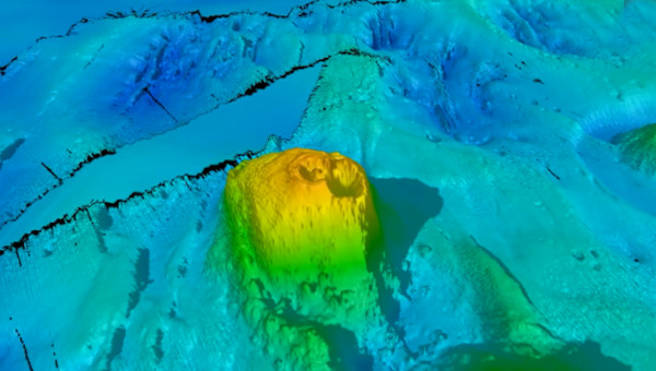
Modélisation d’un volcan sous-marin à double cratère découvert à l’ouest de l’île Macquarie (Source: FOCUS volyage/CSIRO).
————————————————–
 When speaking about volcanoes in Antarctica, one immediately thinks about Mount Erebus (3,794 m) on Ross Island, but the seafloor of the region around the white continent also shows very interesting volcanic features. New high-resolution maps of the seafloor halfway between Tasmania and Antarctica have revealed a chain of underwater volcanoes – or seamounts – whose summits may influence the behaviour of ocean currents above.
These seamounts are located about 4,000 meters below the sea surface and directly in the path of the Antarctic Circumpolar Current which flows clockwise around Antarctica. The Current acts as a barrier that helps keep the icy continent frozen.
Scientists have mapped an area where this barrier appears to be leaking, enabling swirls of warm water to reach the shores of Antarctica and possibly contributing to its melting and to sea level rise.The leak has long been known but the scientists hope the new maps could help predict how the leak will evolve as oceans warm due to global warming and meltwater floods into the Southern Ocean.
The researchers collected ocean data inside the Circumpolar Current from aboard the Australian research vessel Investigator. They also used NASA’s and the French CNES Surface Water and Ocean Topography (SWOT) satellite, which measures the height of the ocean surface from space to know what lies beneath. The satellite measurements revealed a chain of mountains which spans 20,000 square kilometers of a region west of Macquarie Island and the tectonically active Macquarie Ridge. Actually, the chain of mountains includes eight ancient seamount with peaks up to 1,500 meters high and one with a double vent. Four of the seamounts have never been studied before.
The seamounts formed within the last 20 million years and likely play a role in shaping ocean currents around Antarctica. According to the authors of the new map, « the Antarctic Circumpolar Current ‘feels’ the seafloor and the mountains in its path, and where it encounters barriers like ridges or seamounts, ‘wiggles’ are created in the water flow. » These wiggles form eddies that play a major role in transporting heat and carbon from the upper ocean to deeper layers, a critical buffer against global warming.
The researchers explain that knowledge of the depth and shape of the sea floor is crucial to quantify the influence of undersea mountains, hills and valleys on the Antarctic Circumpolar Current and the leaking of heat toward Antarctica. Ultimately, mapping the Southern Ocean will deliver clues about the extent of ice melt in Antarctica and help predict the resulting rise in sea levels.
Adapted from an article on the website space.com.