
![]() La plupart des gens pensent que tous les volcans espagnols se concentrent dans les Iles Canaries et ignorent qu’il existe une très intéressante zone volcanique dans la partie NE de la Péninsule Ibérique, pas très loin de la petite ville d’Olot.
La plupart des gens pensent que tous les volcans espagnols se concentrent dans les Iles Canaries et ignorent qu’il existe une très intéressante zone volcanique dans la partie NE de la Péninsule Ibérique, pas très loin de la petite ville d’Olot.
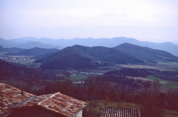
Il s’agit du meilleur ensemble paysager volcanique de la péninsule ibérique. On y recense une quarantaine de cônes volcaniques, en bon état de conservation, et plus de vingt coulées de lave de nature basaltique. La végétation est souvent exubérante, avec des chênes verts et rouvres, ainsi que de belles hêtraies.
Toute cette zone volcanique se trouve actuellement protégée et a été érigée en Parc naturel de la Zone Volcanique de la Garrotxa, qui inclut les 40 volcans. Elle présente une superficie de 12 007 hectares (120,07 km2).
Le centre du parc est formé par la plaine d’Olot dont champ de lave occupe une grande partie (environ 25 km2), par où la lave a coulé en suivant la vallée du fleuve Fluvià, arrivant jusqu’à Sant Jaume de Llierca.
Un autre secteur important est constitué par la vallée tectonique de la rivière Ser, où se trouvent les volcans les plus importants : Santa Margarida et Croscat. Ici, la lave a suivi la vallée par le versant de la rivière jusqu’au Molino de Gibert, après la cascade Sallent de Santa Pau.

Enfin, il existe un troisième secteur constitué par une série de volcans situés dans la vallée de la rivière Llémena et dans celle de l’Adri.
Il y a eu différentes phases d’éruptions au cours de la période moderne, mais on peut les dater toutes autour de la moitié du Quaternaire (voir ci-dessous).
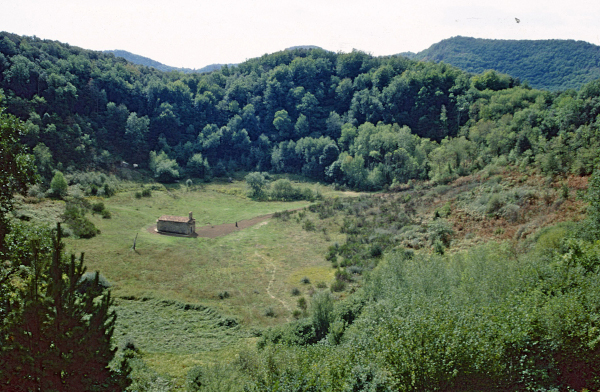
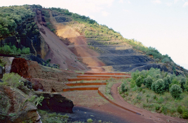
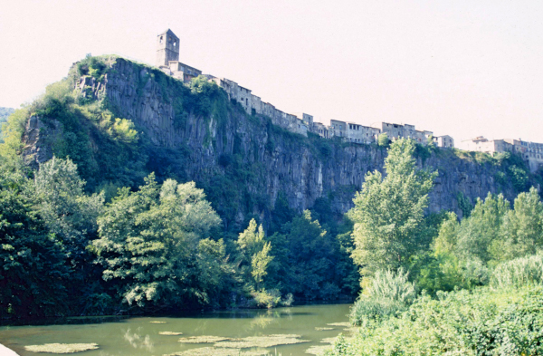
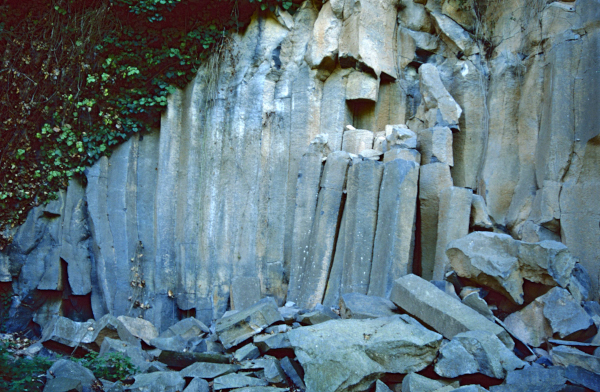
Les cônes volcaniques sont de type strombolien, parfois avec un cratère central (Santa Margarida), d’autres un cratère latéral (Garrinada). Ils sont constitués de scories ou de gros matériaux (Croscat). Il existe également des tables de lave, mises au jour par l’érosion fluviale, comme à Castellfollit de la Roca ou à Sant Joan les Fonts, où on peut voir la constitution interne consolidée en prismes allongés.

°°°°°°°°°°
La dernière datation de l’éruption du volcan Croscat, l’un des plus spectaculaires de la région, avait été effectuée dans les années 1980 en utilisant la technique de la thermoluminescence.
Un groupe de scientifiques espagnols appartenant à différents instituts a mis au point un programme permettant d’analyser chronologiquement les derniers soubresauts éruptifs de cette région. La datation du sol s’est faite au Carbone 14 à partir de matériaux organiques prélevés à la surface de la terre avant le début de l’éruption.
Pour ce faire, les scientifiques ont perforé la couche d’argile que l’on trouve dans le secteur de Pla del Torn, à quelques mètres au NE du cône volcanique du Croscat. Des tests ont été effectués à 12 et 15 mètres de profondeur, à la base de la couche d’argile et à la surface du paléosol.
L’étude des échantillons de pollen et l’analyse palynologique de ce sol pré-éruptif ont révélé que le paysage de la Garrotxa était de type méditerranéen, avec des prairies et des steppes où poussaient, entre autres, des graminées et des astéracées. Des chênes et chênes verts ont également été découverts, ce qui indique que la température était relativement douce et correspondait au début de la période de dégel qui a fait suite au dernier Age de Glace. La présence d’arbres rencontrés au bord des rivières (ormes, aulnes, saules) ainsi que de plantes aquatiques est la preuve que la pluie était fréquente à cette époque.
La datation a révélé que la partie supérieure du sol avait un âge compris entre 13 270 et 13 040 ans et que l’éruption du Croscat a eu lieu juste après cette époque.
Source : Live Science.
Photos: C. Grandpey
———————————————
![]() Most people think that all of Spain’s volcanoes are concentrated in the Canary Islands and are unaware of the very interesting volcanic area in the northeastern part of the Iberian Peninsula, not far from the small town of Olot.
Most people think that all of Spain’s volcanoes are concentrated in the Canary Islands and are unaware of the very interesting volcanic area in the northeastern part of the Iberian Peninsula, not far from the small town of Olot.
This is the finest volcanic landscape on the Iberian Peninsula. It boasts around forty well-preserved volcanic cones and more than twenty basaltic lava flows. The vegetation is often lush, with holm oaks and sessile oaks, as well as beautiful beech forests.
This entire volcanic area is now protected and has been designated the Garrotxa Volcanic Zone Natural Park, encompassing all forty volcanoes. It covers an area of 12,007 hectares (120.07 km²). The park’s core area is the Olot plain, a large portion of which (approximately 25 km²) is covered by a lava field. The lava flowed down the Fluvià River valley, reaching as far as Sant Jaume de Llierca.
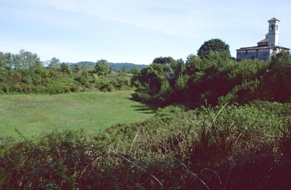
Another significant area is the Ser River tectonic valley, home to the most important volcanoes: Santa Margarida and Croscat (see photos above). Here, the lava followed the valley along the riverbank to Molino de Gibert, beyond the Sallent de Santa Pau waterfall.
Finally, a third area comprises a series of volcanoes located in the Llémena and Adri River valleys. While there have been several phases of eruptions in the modern era, they can all be dated to around the middle of the Quaternary period (see below). The volcanic cones are of the Strombolian type, sometimes with a central crater (Santa Margarida), others with a lateral crater (Garrinada). They are composed of scoria or large materials (Croscat). There are also lava tables, exposed by fluvial erosion, such as at Castellfollit de la Roca or Sant Joan les Fonts, where the internal structure consolidated into elongated prisms can be seen. (see photos above)
°°°°°°°°°°
The latest dating of the eruption of the Croscat Volcano – one of the best preserved of the area – was obtained with the technique of thermoluminescence conducted in the 1980s.
A group of Spanish scientists from several institutes developed a programme to locate chronologically the final moment of volcanic eruptions in the region. Soil dating was carried out using the C-14 dating method with the organic material found on the surface of the earth right before the moment of eruption.
Scientists perforated the clay found in the region of Pla del Torn, a few metres to the northeast of the Croscat volcanic cone. Two tests were carried out, at 12 and 15 metres deep, which reached the base of the clay layer and the surface of the palaeosoil.
Pollinic analysis was conducted with the samples obtained from the surface of this pre-volcano level revealed that the landscape of La Garrotxa was largely Mediterranean with meadows and steppes containing, among others, gramineae and asteraceae. Oaks and holm oaks were also discovered, which indicates that temperatures were mild, a symptom of the beginning of the thawing period following the last Ice Age. The presence of riverside trees (elms, alders and willows), as well as aquatic plants are proof that during that period there was a lot of rainfall.
Dating has shown that the age of the upper part of the soil dates back approximately between 13,270 and 13,040 years and that immediately after that moment the eruption of the Croscat Volcano took place.
Source : Live Science.
